Geospatial Data Integration
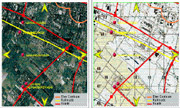
Recent growth of the geo-spatial information on the web has made it possible to easily access a wide variety of geo-spatial data. Accurately integrating diverse geo-spatial data remains a challenging task, since geospatial data obtained from various data sources may have different projections, different accuracy levels, and different inconsistencies. One of the major applications of integrating these data is to automatically identify objects, such as roads or buildings, in the satellite imagery and annotate these objects with the information from other data sources. GIS and computer vision researchers have worked on identifying objects in the satellite imagery for a long time. However, the resulting algorithms take a large amount of processing time and may produce inaccurate results. The goal of the project is the design and implementation of a novel information integration technique, which utilizes geospatial and textual data available on Internet to automatically and efficiently integrate geo-spatial data and identify objects.
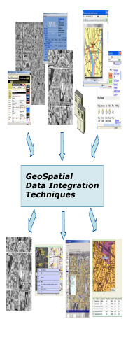
The main objective of this research sub area is to provide a transparent layer for retrieving and integrating data from several heterogeneous databases and online sources. The unifying framework for integration is the objects' time and space dimensions. At IMSC, several immersive environments, such as 2020Classroom, require integration of various data (e.g., course-related material or news) form different data sources to provide rich content to the users. These environments have also rich spatial and temporal characteristics (see the Immersidata report) and it is very natural to query and access objects based on their space and time dimensions (e.g., user looking to location X, Y, Z at time t, hence, all the objects relevant to that area and time should be accessed and displayed). The techniques designed and developed in this research can be utilized to efficiently integrate distributed spatio-temporal information. In particular for this year's achievements, the results would enable accurate annotation of spatial objects in the imagery using information integration.